A bug in the matrix or just the radar? This is no normal cloud-shape, is it?
18 comments
looks a bit like convective cells to me! they happen in summer (as long as there is sufficient surface heating to drive the convection) - they're like bubbles in boiling water.
It looks like you've got high pressure over there though... the high pressure may just limit the cloud heights and intensity of the precipitation?
Edit: these look a little too big to be pop-up cells, but they still look more convective (instead of frontal). a bit suspiciously too round, though.
Do they stay consistent and track across the sky, or are they more bubble-like?
2nd edit: looks like I'm wrong and it is a radar artefact :) (this is why looking at radar timelapses is more important than just single-frames!)
3rd edit: it's not an artefact, it's a real signal! it's insects!
what a roller coaster, and the ominous unexplained insect edit is a cherryon top
aha here's a full explanation of the thought process:
no other weather report matches these patterns
they're suspiciously round and not blobby like real clouds
they're each suspiciously localised around the radars in the network
there are lots of types of radar artefacts, including close-to-radar ground-clutter (this is what I assumed it was) but it's too consistent and large of a signal for that
so it must be something uniform, in the air instead of on the ground, that isn't rain
bugs are about the size of a big rain drop! enough to be picked up as a strong signal by the radar and enough to prevent the radar from seeing long distances
It's also been flying-ant-day recently across Europe
A lot of weather radars have localized noise, I’ve noticed
The screenshot below has only one radar selected. Maybe the app you are using is displaying data from more than one radar?
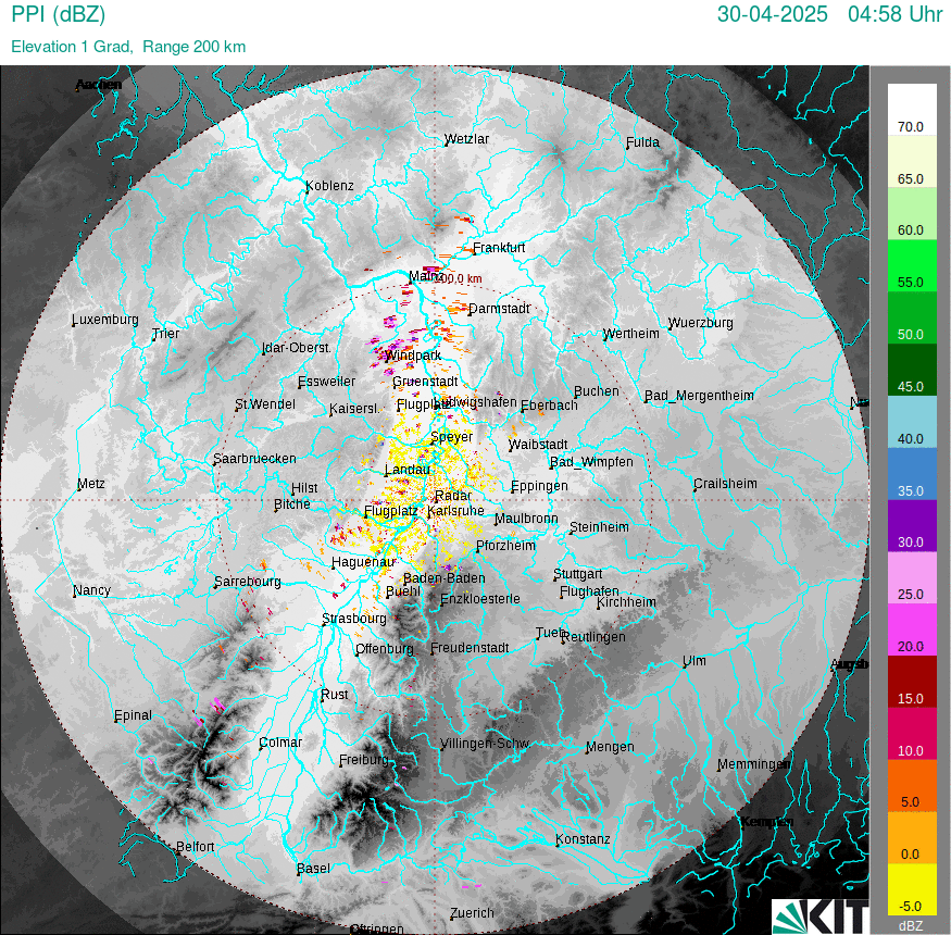
Oooh, excellent point! The german weather service (DWD, which OP is using) has 17 operational weather radar... looks like an artefact to me!
EDIT: it's not an artefact, but insects!
Bingo! Nice find.
Could be, the app uses RainViewer as source, their sources for Germany are:
I don’t know my German geography, but I’d be curious how topology plays into this.
Doesn't look like orographic cloud to me! Usually they have ripples in em
Plus, the Alps are only really in the South and nowhere near Berlin (which is pretty flat) - so you'd see more enhancement in the South than the North, whereas these are pretty evenly spaced
The sat 24 IR view doesn't seem to match up very well with what you've posted, so it may just be noise, or a corrupted data load.
The screenshot is 6 days old.
But the sateliete image of the above time and location doesn't really fit either.
looks a bit like convective cells to me! they happen in summer (as long as there is sufficient surface heating to drive the convection) - they're like bubbles in boiling water.
It looks like you've got high pressure over there though... the high pressure may just limit the cloud heights and intensity of the precipitation?
Edit: these look a little too big to be pop-up cells, but they still look more convective (instead of frontal). a bit suspiciously too round, though. Do they stay consistent and track across the sky, or are they more bubble-like?
2nd edit: looks like I'm wrong and it is a radar artefact :) (this is why looking at radar timelapses is more important than just single-frames!)
3rd edit: it's not an artefact, it's a real signal! it's insects!
what a roller coaster, and the ominous unexplained insect edit is a cherryon top
aha here's a full explanation of the thought process: